Ultra-Fast Fix
480MHz processor delivers centimeter RTK fix in seconds.
RTK that holds where autonomous machines usually lose their fix — under orchard canopy, inside tunnels and through heavy EMI. The Q.MAX5 pairs a multi-band Septentrio Mosaic-X5 engine with an industrial 6-DOF IMU, so position and heading keep updating after the sky is blocked. Built for autonomous tractors, UGVs and survey platforms on land — and for yacht autopilot and hydrographic survey duty offshore, where water-surface multipath and wave motion never stop.
The Q.MAX5 is a complete positioning receiver, not a bare GNSS breakout. Around the Septentrio Mosaic-X5 core, which tracks GPS, GLONASS, Galileo, BeiDou, QZSS and NavIC on L1/L2/L5, on-module fusion with the ADI ADIS16505 6-DOF IMU supplies continuous Dead Reckoning when the sky is blocked. RTK holds 0.6 cm + 0.5 ppm and PPK 0.5 cm + 0.5 ppm at up to 100 Hz. Comparing the two Septentrio mosaic cores? See the mosaic-G5 vs Mosaic-X5 comparison.
Integration is open: NMEA 0183, SBF, RTCM 2.x/3.x and UBX pass-through leave over two 3.3 V TTL UARTs, USB 2.0 High-Speed or CAN 2.0B / CAN-FD, with 1PPS timing under 20 ns. NTRIP client/server is built in and the MicroSD slot logs PPK raw data without gaps; a 3.5–60 V input at 1.8 W over −40…+85 °C suits 12 V, 24 V and 48 V machinery.
01 GNSS & positioning performance | |
|---|---|
| Parameter | Value |
| GNSS core | Septentrio Mosaic-X5 multi-frequency, full-constellation receiver |
| Constellations | GPS (L1C/A, L1C, L2C, L2P, L5), GLONASS (L1CA, L2CA, L3), Galileo (E1, E5a, E5b, AltBOC), BeiDou (B1I, B1C, B2I, B2a, B3I), QZSS (L1C/A, L1C, L2C, L5), NavIC (L5) |
| Standalone accuracy | Horizontal 1.2 m · Vertical 1.9 m |
| RTK accuracy | Horizontal 0.6 cm + 0.5 ppm · Vertical 1.0 cm + 1 ppm |
| PPK accuracy | Horizontal 0.5 cm + 0.5 ppm · Vertical 0.8 cm + 1 ppm |
| TTFF | Cold start < 45 s · Hot start < 2 s |
| Velocity accuracy | 0.03 m/s |
| Anti-interference | Septentrio AIM+ dynamic notch filtering with spoofing detection |
02 Inertial sensor (ADI ADIS16505-2BMLZ) | |
|---|---|
| Parameter | Value |
| Sensor type | Industrial 6-DOF MEMS combo (3-axis gyroscope + 3-axis accelerometer) |
| Gyroscope (triaxial) | Range ±125 / ±500 / ±2000 °/s · in-run bias stability 2.3 °/hr · ARW 0.13 °/√hr · misalignment ±0.25° |
| Accelerometer (triaxial) | Range ±78.4 m/s² (±8 g) · in-run bias stability 26.5 µm/s² (X/Y) · VRW 0.035 m/s/√hr |
| Sampling & output | Up to 2000 Hz internal sampling · filtered output at 100 / 200 Hz |
03 Processing, memory & storage | |
|---|---|
| Parameter | Value |
| MCU | STM32H743VIHx · Arm Cortex-M7 @ 480 MHz · 1027 DMIPS · double-precision FPU · 1 MB on-chip SRAM |
| System RAM | ESP-PSRAM32 · 4 MB external PSRAM cache · zero packet loss on high-frequency streams |
| Firmware storage | W25Q128JVS · 128 Mbit (16 MB) NOR Flash with XIP (execute-in-place) |
| Data logging | MicroSD card slot over SDIO · long-term raw logging for PPK post-processing |
04 Protocols & interfaces | |
|---|---|
| Parameter | Value |
| Protocols | NMEA 0183 v4.10 · SBF (Septentrio Binary Format) · RTCM 2.x/3.x · UBX-compatible pass-through · NTRIP client/server |
| UART | 2× UART (3.3 V TTL, up to 921,600 bps) |
| USB | 1× USB 2.0 High-Speed (Type-C / header) for local web GUI and streaming |
| CAN | 1× CAN 2.0B / CAN-FD (optional onboard transceiver) |
| PPS | 1× PPS output (time pulse, < 20 ns) |
| Antenna inputs | Main GNSS + auxiliary GNSS (dual-antenna heading / moving baseline) + 2.4 GHz WiFi for local web setup |
05 Electrical & physical | |
|---|---|
| Parameter | Value |
| Input supply (VIN) | 3.5 V min · 12 / 24 V typical · 60 V max (reverse-voltage protected) |
| Power management | TI TPS54260DRCR step-down · 2.5 A continuous output · Eco-mode · Over-current protection (frequency foldback) · Thermal shutdown |
| Power consumption | 1.8 W typical · 2.5 W max (RTK active + IMU streaming + SD logging) |
| Operating temperature | −40 °C to +85 °C (industrial grade) |
| Storage temperature | −45 °C to +105 °C |
| Dimensions (L × W × H) | 45 × 35 × 12 mm (mainboard, PCB only) |
| Weight | 32 g (base board without antenna) |
Tractor auto-steer, precision spraying and robotic harvesting that keep path lock under heavy orchard canopies.
Excavator grade control and drone LiDAR/photogrammetry mapping with zero-loss PPK raw data logging.
Centimeter-level Dead Reckoning in urban canyons, tunnels and high-EMI industrial complexes.
Centimeter positioning and attitude tracking for autonomous yachts, unmanned surface vessels and hydrographic survey boats — holding lock through water-surface multipath and wave motion.
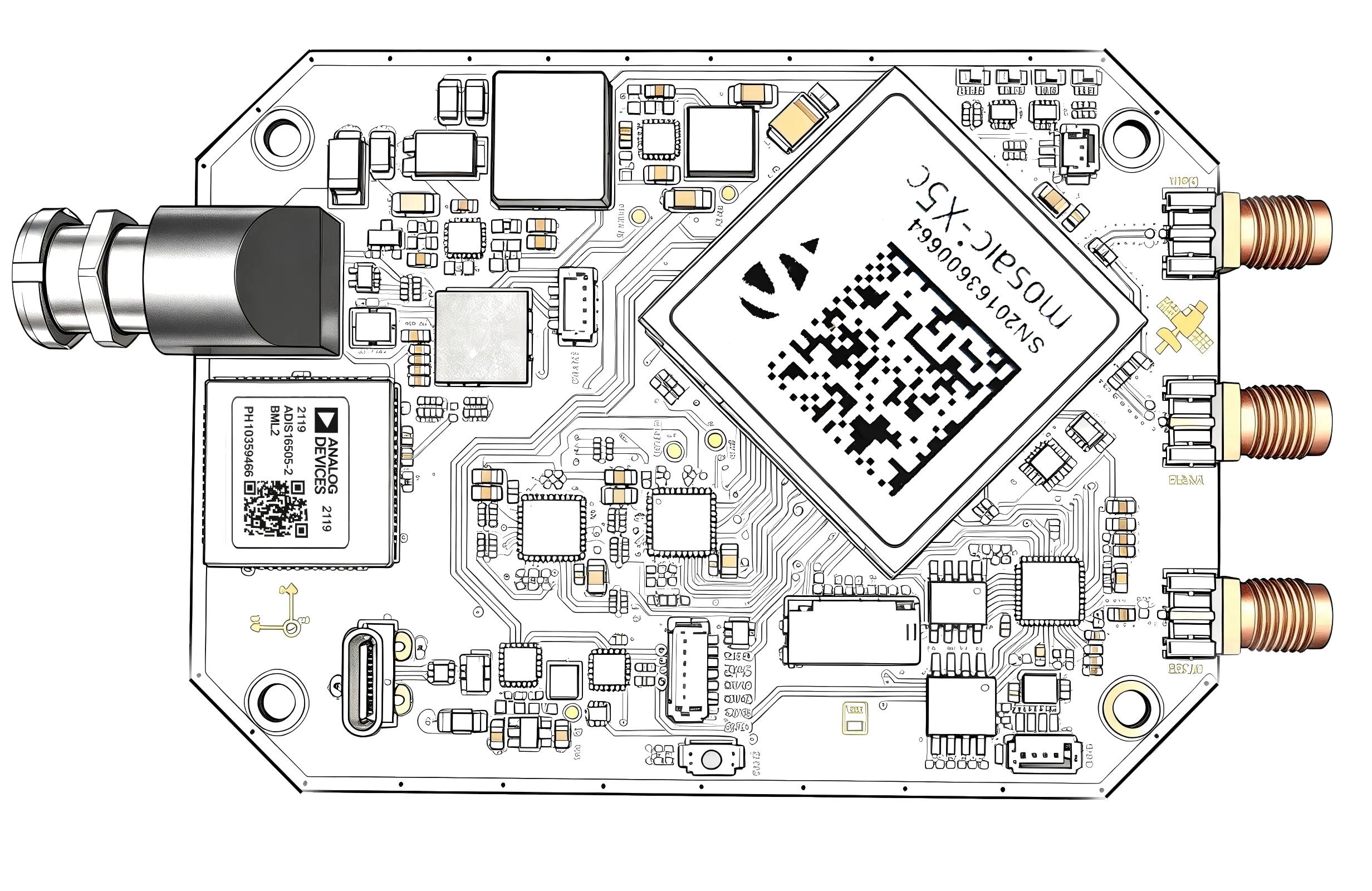
480MHz processor delivers centimeter RTK fix in seconds.
Main and auxiliary GNSS antenna inputs give dual-antenna heading (moving baseline), and the ADIS16505 IMU keeps heading and attitude valid when the fix degrades.
ADIS16505 industrial-grade IMU: 6-DOF MEMS, holds trajectory under canopy, in tunnels, and through EMI bursts.
Septentrio Mosaic-X5 with AIM+ holds lock in heavy EMI and multipath.
4MB PSRAM buffer plus onboard MicroSD for full PPK post-processing.
TI TPS54260 step-down (3.5 V-60 V, 2.5 A, Eco-mode) with over-current protection and thermal shutdown; 1.8 W typical draw keeps self-heating low on 12 V, 24 V and 48 V machinery.
128Mb dedicated storage with XIP, tamper-proof security and instant loading.
Configure your module locally in the browser — no cloud account, no software install.
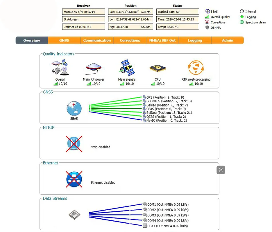
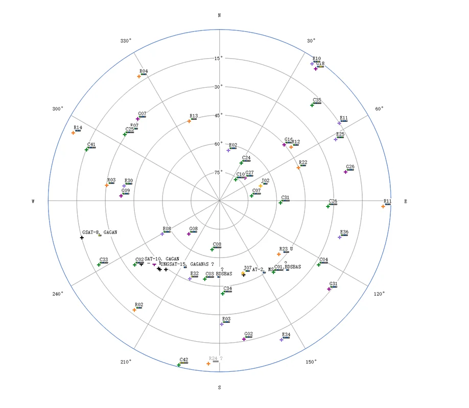
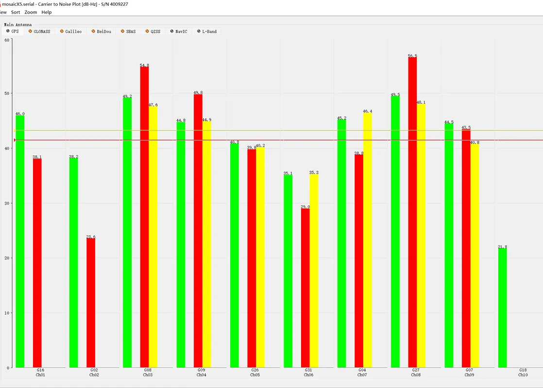

Water-surface multipath and constant pitch and roll are what break a GNSS-only fix offshore: AIM+ keeps carrier lock while the ADIS16505 IMU holds heading through wave motion and bridge shadowing.

Tractor auto-steer and precision spraying under the canopy, where the Mosaic-X5 core with AIM+ anti-jamming holds the RTK fix.

Dead Reckoning carries the position indoors between yard and racking, and the 3.5–60 V input runs straight off the vehicle bus.

MicroSD logging with a 4 MB PSRAM buffer records raw GNSS and IMU observations without gaps, ready for PPK post-processing.
Q.MAX5 supports flexible OEM integration — protocol adaptation, custom firmware and application-specific hardware.
The questions integrators ask before choosing a marine RTK module — answered from the published specification.
Combining the Septentrio Mosaic-X5 GNSS core with Analog Devices' ADIS16505 IMU ensures continuous centimeter-level positioning (Dead Reckoning) even when GNSS signals are lost under dense tree canopies, in tunnels, or during heavy electromagnetic interference (EMI).
One board covers what usually takes two or three. Against a GNSS-only RTK module: the same Septentrio Mosaic-X5 RTK engine, but with an on-module ADIS16505 6-DOF IMU, so Dead Reckoning and roll, pitch and yaw keep running when the satellite fix drops — a GNSS-only board simply stops reporting position. Against a dual-antenna GNSS compass: no separate compass is needed — the main and auxiliary GNSS antenna inputs give Q.MAX5 a dual-antenna heading (moving baseline), and the on-module IMU keeps heading and attitude running when the fix degrades or the vessel sits in a bridge shadow. Against boards that are configured with vendor software over a cable: Q.MAX5 exposes a 2.4 GHz WiFi antenna for local setup and runs its built-in web configuration tool in the browser, so the module is up and configured in minutes with no cloud account and no software install. Send us the module you are comparing against and we will map the parameters side by side.
Q.MAX5 uses a TI step-down converter instead of a linear regulator, so conversion loss and self-heating stay low, and the converter adds over-current protection with frequency foldback and thermal shutdown; the input is reverse-voltage protected. The values are in the specification table above.
Yes. Water surfaces and GRP or steel hulls are strong multipath reflectors, which is what the Septentrio Mosaic-X5 core with AIM+ anti-jamming and anti-spoofing is there for: it keeps lock where a GNSS-only receiver starts jumping. The onboard ADIS16505 6-DOF IMU feeds Dead Reckoning plus roll/pitch/yaw fusion, so position and heading survive wave motion, bridge shadowing and quay-side blockages. The module runs straight from the vessel bus, and CAN 2.0B / CAN-FD links it to the control network; NMEA 2000 is not part of the standard configuration and can be added as a custom upgrade.
Yes. Q.MAX5 outputs standard NMEA 0183 for the chartplotter and autopilot, and its marine behaviour comes from two elements: the Septentrio Mosaic-X5 core with AIM+, which suppresses the water-surface and GRP or steel-hull reflections that pull a GNSS-only receiver off its fix, and the ADIS16505 6-DOF IMU, which holds roll, pitch and heading through wave motion and keeps Dead Reckoning running under bridges or alongside tall quays. NMEA 2000 is not part of the standard configuration and can be added as a custom upgrade.
Q.MAX5 is a board-level module, so the antennas are supplied by the integrator — the antenna inputs are listed in the specification table above. At sea, a multipath-suppressing choke-ring GNSS antenna is the common choice on yachts and survey boats: it cuts the water-surface and hull reflections before AIM+ has to reject them.
Q.MAX5 fuses the ADI ADIS16505 6-DOF IMU on module with the GNSS solution and provides Dead Reckoning plus roll, pitch and yaw fusion — that is what holds position and heading through wave motion and short outages. A coupling class (loose or tight) and a dedicated heave output are not part of the published specification; send us the requirement and we will confirm what the current firmware provides.
It can feed both: centimetre-level RTK plus roll, pitch and yaw go to a docking or autopilot controller, and the MicroSD logger stores raw GNSS and IMU observations for PPK in LiDAR or photogrammetry post-processing.
NMEA 0183 v4.10 is supported natively over the two UARTs and USB, which is the format most chartplotters, autopilots and onboard PCs accept. NMEA 2000 is not part of the standard configuration — it can be added as a custom upgrade. CAN 2.0B / CAN-FD is available on the optional onboard transceiver for direct connection to the vessel network.
Q.MAX5 is an OEM module rather than a sealed marine enclosure, so no IP rating is published: the housing, connectors and any salt-spray protection are defined by the integrator’s design.
Goods are quoted FOB Shanghai Airport. The default carrier is DHL Economy, freight is prepaid by the seller and added to the invoice, and delivery to the airport is free of charge. Air freight takes 7–10 days and express courier 3–5 working days, depending on the destination region and the carrier’s official tracking. Main markets are Europe, the Middle East, the USA and South America; shipping is worldwide.
Discounts are granted at the seller’s discretion according to the project volume. For special projects and long-term partners, terms and pricing are negotiable — tell us the expected volume and the deployment plan and we will quote accordingly.
Every unit carries a 2-year warranty from the shipment date: defects caused by the product itself are repaired or replaced free of charge, and human damage is charged at parts cost only. Mechanical spare parts are guaranteed to be available for 15 years (cellular modules and batteries follow the upstream supplier’s policy). International returns and replacements follow a written RMA process — request within 15 business days, and never ship goods back before we approve the return and issue an RMA number. Duties, freight and other return costs are allocated according to the cause, and a return whose total cost exceeds 15% of the goods’ value may be refused or settled locally instead. Read the full quality-assurance and return policy.
This website provides information about Qumtrix's IoT engineering, OEM/ODM development and manufacturing services.
The text, images, logos, graphics and technical content on this site belong to Qumtrix or the relevant rights holders and may not be copied or used commercially without authorisation.
Product specifications, technical information and other content on this website are provided for general informational purposes and may be updated without prior notice.
We are not responsible for the content or availability of third-party websites.
We make reasonable efforts to keep the information on this website accurate and up to date, but we do not warrant that all information is complete, current or error-free.
For questions regarding these Terms of Use, please contact us at sales@qumtrix.com.
When you send an inquiry or a partner application: company, your name, business e-mail, country, the products or quantities you are interested in, your message and an optional phone number. When you subscribe: your e-mail address. For anonymous statistics: the page, an approximate country, reading time and clicks.
To answer your inquiry and perform our contract (Art. 6(1)(b)), and for anonymous statistics under legitimate interests (Art. 6(1)(f)) which you can switch off at any time. Analytics details are deleted after 400 days, the full IP address is masked after 30 days, audit logs after 730 days.
Access, correction, export, deletion, objection and restriction. Write to admin@qumtrix.com — we answer within 30 days.
qumtrix.com sets no advertising or tracking cookies. Visits are counted anonymously — page, approximate country, reading time, clicks — with no cookie and nothing stored on your device for measurement.
qm_cookie_consent in your browser's local storage remembers whether you switched statistics on or off. It is strictly necessary, stays on your device and is never sent to us.
Use Cookie settings in the footer at any time; switching statistics off takes effect immediately and no further measurement is sent. Do Not Track and Global Privacy Control are always honoured.
Every unit carries a 2-year warranty from the shipment date. Defects caused by the product itself are repaired or replaced free of charge; damage caused by human factors that needs parts replaced is charged at parts cost only. Mechanical spare parts are guaranteed to be available for 15 years.
Send a written request with the order number, product details, quantity, reason and supporting documents (photos, video, test data) within 15 business days after the issue is found. No goods may be returned without our written approval and an RMA number.
Return freight, destination duties and re-assessed Chinese import duties and VAT follow who is at fault. If the total return cost exceeds 15% of the goods' residual or contract value, we may refuse the return or ask you to dispose of the goods locally, at your cost.